
At 7:45 I catch the first Bus to Los Quenes, and an hour later, I am ready to hike again!
Behind a campground under shady pines I leave the village and walk on a dirt road up the valley of the Rio Claro de Teno. Soon the river disappears in a gorge and for some hours I won't see it again.


First I pass some irrigated pastures with farmhouses away from the road, but most of the time the road crosses dry bushland. The walking is not very interesting, but the colourful mountains are coming closer...

Fortunately there is no traffic, and even at the large estancia Los Manantiales I see nobody.

The first walking hours are dry and hot. Just after Los Manantiales the first creeks appear.
The road slowly fades away and behind the estancia there is just a rough, stony track, which doesn't seem to get much use.
In the afternoon I pitch my tent on a lush, green meadow, hidden from the road and near a small creek. For the first time on this trek there are some mosquitoes, o.k water and high temperatures...

After having dinner I go for an afternoon walk further along the dirt road. The wet tangled forest nearby in the vicinity of a lot of small creeks with thick undergrowth, lush mosses and twisted trees reminds me a bit on the rainforest.

 |
| Wet forest |
The Rio Teno de Claro forms a flat basin at the foot of the glaciated volcanoes Planchon and Peteroa, which form the border to Argentina. This wide landscape is dominated by stands of Andean Cypreses. They don't get higher than about 5 meters but apparently are very tough and get very old.


In the forest I photograph a nice little quail with a hood.

I walk a short distance cross country, and get to a place, overlooking a steep basalt gorge, with column shaped wall and a waterfall plunging into the abyss. Very impressive!


Next morning, before the sun reaches the valley bottom, I get again a view into the tight, dark gorge from above a bridge on the track.

But soon enough the sun ins back and makes for crystal clear, sharp morning light. This valley bottom which resembles more a high plateau is really unique as I will find out later. In geological history it is probably not very rare that burning lava flows filled the valley...
The road eventually has turned into a trail, which I like much more....


When the trail branches I turn left, towards the slopes of Volcan Peteroa. I would like to explore the volcanic area, before I reach Jan's route again. Meadows full of high grass and flowers border barren areas full of dark rocks.

Rather soon I realize, that my planned route looks quite difficult because of a deeply cut gorge, so I return to the GPT. There I need to cross a river which looks swift. It is black from the volcanic ashes, so it is hard to tell how deep it is. Anyway, I keep my Trail running shoes on the feet and wade the creek without difficulties. In this dry environment the water soon evaporates.

Dark from volcanic ashes
I leave the valley by a long, steep climb. My backpack is still heavy with the food for 19 days, therefore I need to rest frequently...
But sooner or later every ascent ends and I get to a vast, open plateau, where the walking is easy again.
Before reaching a hut, which I spotted from a distance, I make camp in a grassy syncline.

It doesn't take long, before three riders turn up. They are friendly and I learn that they are government inspectors, looking after the cattle. Soon after I get a visit by two old arrieros. They tell me, that they are in charge of looking after 600 cows!

Later I take a short evening walk to enjoy my beautiful surroundings and the sunset, which illuminates the tips of the range with red colours!


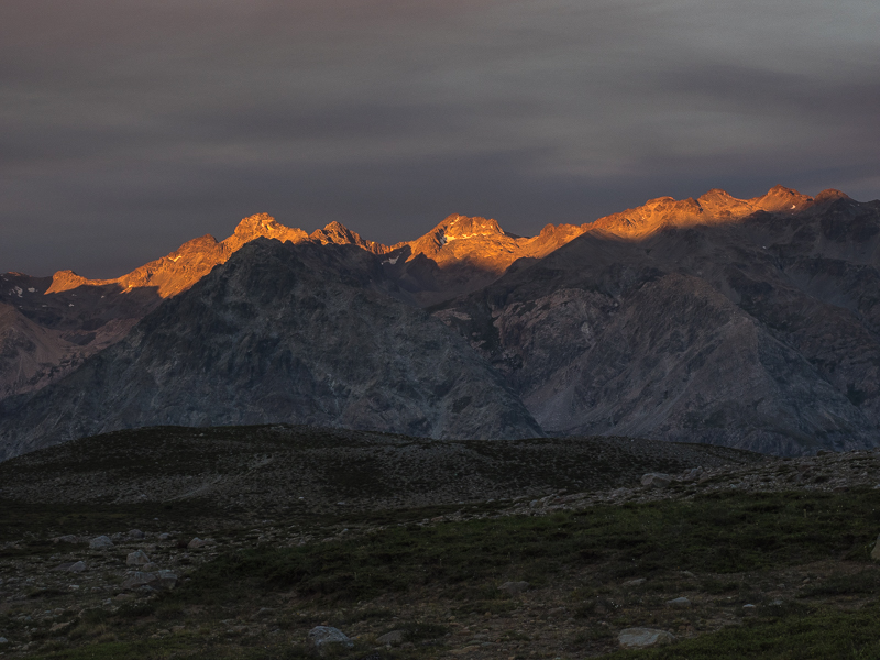
Before the night comes in full swing the mountains turn ash grey.

In the morning I get quite chilly from the ground. When I pack, I realize, that it was not so clever to camp in the syncline. Exactly where I was lying, there is a puddle of water now...
I walk close by the hut of the arrieros and then start to climb out of the large valley. It is still cool and shady, but it doesn't take long for the first rays of the sun to rise above the mountains.


After ascending to a Pass at 2345 m the terrain becomes wide and flat.


For a while I descend with only little altitude difference. Although this must be good grazing ground, there are hardly any cows.

After a rocky descent I reach another "Black Water" river, which I wade barefoot. Here I get the first view of the steep walled canyon which is formed by Rio Colorado. I need to get down there...


Up to now the trail was mostly easy to follow, but now it seems that it has completely faded. I walk upward along the open hillsides until I reach another pass at 2364 m, which offers good views into the canyon. Unfortunately it is a little hazy.

Surprisingly here a good trail following the mountainside starts again. At a number of small, but steeply carved gullies, attention is needed not to do a wrong step...
Hidden in the gorges some beautiful flowers are blooming.


Down below is the creek to which I need to descent. I hope for the trail to continue, but not so, I have to negotiate a very steep, nasty scree slope to get down. Even from above the sound of the river tells me, that something big awaits me. Therefore I look for a good crossing point, because I know, that this creek which comes directly thundering down from the glaciers of Volcan Azufre, will be very difficult. I reach the river where it splits in two arms. When I see the turbulent dark whitewater I know there is absolutely no chance to cross here, so I don't even put a toe into the water...
The gpx-Track shows the crossing further down, so I decide to give it a try and turn downstream.

The walking along the steep, rocky shore is very difficult, and at one point I break the lower segment of a hiking pole when it is trapped between two rocks...
At the place the gpx-track shows the crossing, it is not even possible to reach the river, which has entered a gorge.
I continue following the river, because I still have the faint hope that I can descent directly into the Rio Colorado Canyon, but soon I realize that it is impossible along the vertical basalt cliffs.
There is no place to camp in this steep terrain, I am tired but don't want to go the same difficult way back.
On my GPS-map at one spot it looks possible to climb out of the valley. First the ascent is quite o.k but soon becomes more and more difficult. In places I need my hands as well. All the while I know, that I might need to turn back at some point. And of course, the descent is always harder...
But I am lucky, it doesn't get more difficult and I reach a flat plateau I saw in the afternoon from above.

There is even a creek and about 30 horses enjoy the green pastures on this hidden, flat paradise.
Although I descended for a good part of the day, I have climbed about 1400 meters...
It was an exciting, beautiful, hard day and I hope that tomorrow I find a way to the Rio Colorado!

In the morning I walk first to the edge of the plateau where I was camping to get a better view in the canyon and hopefully find a route on which I can descend. The grassy plateau is flanked by steep mountainsides and the abyss of the Rio Colorado.


For a while I am hopeful, but at some point there are always steep cliffs.

Finally I turn back and ascent to my route of yesterday. I hope that the glacier fed creek is less wild in the morning. But probably even at altitude the night was too mild so that the snow melt continued and the river is still wild, what I can see with my binoculars from above.
So I recede to the pass where I had good views into the canyon.
Now the light is much better and I stay for a while experiencing this unique place.


I descent trailless towars the direction which looks promising. But unfortunately it is nowhere possible to get a view down into the depth of the gorge, so again the terrain becomes too steep.
My last resort is the valley I followed yesterday in flat areas. It reaches the Rio Colorado downstream from the gpx-track crossing point. But again, no luck.
I am sure at some place it must be possible to go down to the river, but even then I might not be able to cross it or follow it in the canyon, so I decide to go back to Los Quenes, take the bus and continue my walk from Siete Tazas, the original starting point of the GPT. From there I want to go to the Rio Colorado again, to scout it from the other side.
I am surprised, as this route is marked by Jan as confirmed. Maybe the creek is sometimes much lower?
Across the trailless slopes I head back to the flat valley.

I find a beautiful spot, the temperature is nice, so I decide to pitch camp early and wash me and my clothes...
Surprisingly there are many ants, so I need to move the tent once...

In the evening I take a walk and photograph some smaller birds and a kind of grouse.


When I get back to the Camp of the Arrieros (Puesto) they invite me for breakfast! While Juan, the thinner one doesn't talk much, Cajon who is 65 chats a bit with me, although the conversation is limited because of my poor spanish. I show him the creek I couldn't cross, and he says it is indeed impossible...But there is another route to the Rio Colorado, where there is a bridge, but I can't understand his description!
A big pot with soup is simmering on the open fire, while Cajon is preparing Nescafé and I get Bagels with tuna!


As I want to reach Los Quenes again today, I need to hurry a bit, but still enjoy the surroundings, this time from the other direction...


My hips are a little chafed by my backpack, therefore I use clothes as cushion...
At around noon I reach my first camp, and know, that I still have a long way to go...
After every hour, I reward myself with a five minute break and half a liter of water, which is badly needed...
Near Los Manantiales I see a poor horse which is trapped in the wire of a fence. I take a picture and luckyli meet an arriero from the estancia a little later, so they hopefully can free the animal.

Unfortunately no car is passing by, so I need to walk the whole distance again and arrive after 43 kilometers in the evening on the large and busy campground of Los Quenes.
It is weekend, no wonder that the village as well is full of chilean tourists. I enjoy a well deserved Pizza in town, before I finally go tired to sleep.

Keine Kommentare:
Kommentar veröffentlichen